The waters surrounding the British Caribbean territories have long remained a realm of mystery.
Now, a groundbreaking scientific expedition venturing beyond the islands’ shallow coastal waters has unveiled a previously unknown underwater mountain range, a massive “blue hole,” coral reefs seemingly untouched by the effects of climate change, and a host of marine species never before documented.
Operating continuously for six weeks, researchers deployed specialized cameras and equipment to withstand extreme underwater pressure, capturing footage from depths of up to 6,000 meters (19,700 feet).
Navigating the waters around the Cayman Islands, Anguilla, and Turks and Caicos proved challenging, as the team relied on outdated maps riddled with inaccuracies and omissions.
The UK Centre for Environment, Fisheries and Aquaculture Science (CEFAS) has exclusively shared their remarkable footage and discoveries with BBC News.
The UK government holds shared responsibility for safeguarding the natural heritage of these islands, where up to 90% of Britain’s unique species are found, alongside other British Overseas Territories.
Scientists now emphasize the urgency of protecting this “relatively pristine” environment from the growing threats of climate change and pollution.
“This marks the initial exploration into environments previously unseen and, in some instances, unknown,” states Prof. James Bell, who leads the expedition aboard the British research vessel RSS James Cook, alongside scientists from the three islands.
“Just yesterday, we encountered a unique type of swimming sea cucumber, the identity of which remains a mystery,” he added, describing the biodiversity observed as “really, really astonishing.”
The Cayman Islands, Anguilla, and Turks and Caicos are home to 146 endemic species, a number that is expected to increase as a result of this research expedition.
The team meticulously documented nearly 14,000 individual specimens and identified 290 distinct types of marine creatures, with further scientific analysis needed to corroborate these findings.
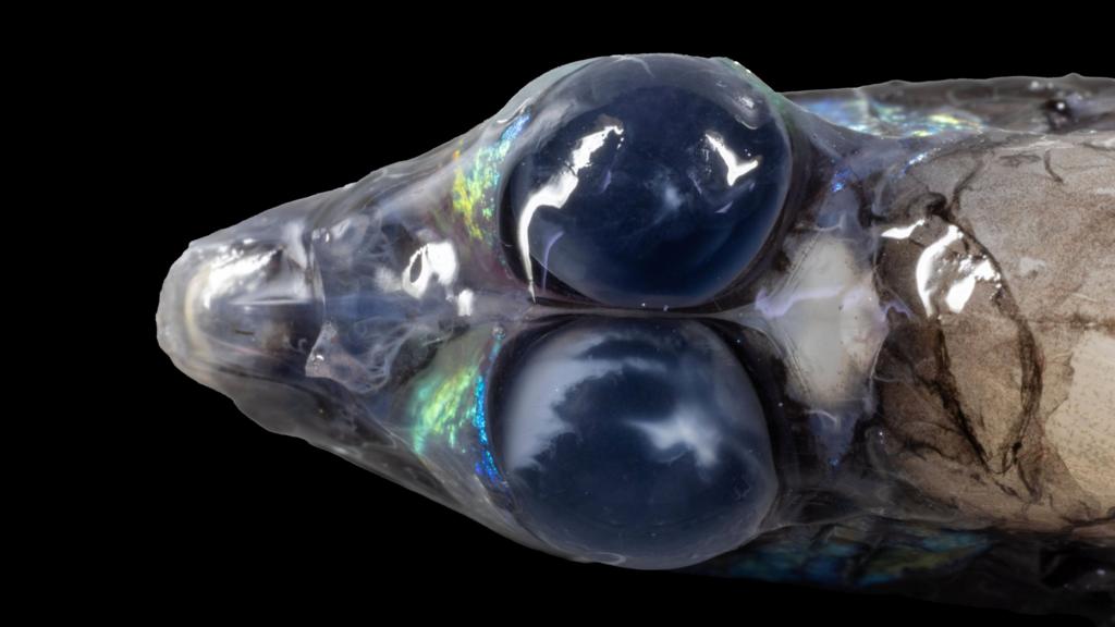
Among the remarkable discoveries were a pelican eel with a bioluminescent pink tail that flashes red to attract prey, a barreleye fish with upward-pointing tubular eyes adapted for spotting prey silhouettes, and a dragonfish equipped with a glowing lure beneath its chin.
Speaking to BBC News while the ship navigated the uncharted underwater feature known as Pickle Bank, Bell remarked, “We’re uncertain of our proximity to it. Mapping it accurately without risking grounding is quite challenging.”
The team ultimately determined that the mountain, located north of Little Cayman Island, rises from a depth of 2,500 meters (8,200 feet) to approximately 20 meters (65 feet) below the sea surface.
Footage reveals a vibrant underwater landscape, with a mountainside ablaze with blue, yellow, and orange hues, teeming with marine life – golden coral towers standing alongside brain-like coral formations.
The team captured images of fish darting among gorgonian whip coral and jelly-like orange sea sponges in proximity to black coral.
They have identified one of the healthiest and most diverse reefs in the region, spared from the devastation caused by stony coral tissue loss disease, which has plagued other parts of the Caribbean. The reef’s depth and the mountain’s steep slopes likely offer it some protection, at least for the time being.
Deep-water, or mesophotic, reefs are generally too deep to be affected by rising ocean temperatures – primarily driven by climate change – which have damaged 80% of the world’s corals since 2023.
Using deep-sea cameras and echo-sounders deployed from the ship, the researchers mapped nearly 25,000 square kilometers (9,700 square miles) of seafloor and captured 20,000 photographs, including images of bioluminescent lanternfish and otherworldly cephalopods.
“We possess a greater understanding of the surface of Mars or the Moon than we do of our own planet’s depths. Satellites can be deployed to map them within weeks,” Bell explains.
“Such rapid mapping isn’t possible for our ocean. We must map it incrementally, utilizing acoustic instruments aboard ships,” he adds.
In Turks and Caicos, the team identified a previously uncharted feature – an extremely steep, 3,200-meter (10,500-foot) high mountain ridge stretching 70 kilometers (45 miles) along the seabed, west of Gentry Bank.
They also made the astonishing discovery of a massive, vertical sinkhole, known as a blue hole, located 75 kilometers south of Grand Turk bank, which formed as a result of a cave collapsing inward.
“Imagine scooping out a section of the seafloor with an ice cream scoop. That’s essentially what we observed – a crater approximately 300 meters (980 feet) wide and extending 550 meters (1,800 feet) below sea level,” Bell describes.
They believe the blue hole’s steep walls could potentially make it the deepest in the Caribbean region, rivaling Belize’s renowned Great Blue Hole.
While blue holes are typically devoid of life, cameras lowered into this newly discovered formation revealed the presence of small sponges, a species of urchin called large spatangoid, and a diverse array of fish species.
Furthermore, 25 kilometers (15 miles) north of Anguilla, the researchers investigated reports from local fishermen who had inadvertently retrieved coral fragments in their nets. The team confirmed the existence of a 4-kilometer (2.5-mile) reef characterized by mosaics of coral flourishing within sponge “gardens.”
They also encountered black coral specimens that could potentially be thousands of years old, making them among the oldest ever documented.
“This indicates that these environments are truly pristine and healthy,” Bell affirms.
Scientists are particularly interested in these deep-water areas and steep mountain formations because they can channel nutrient-rich waters upwards, providing valuable feeding grounds for marine animals and potentially serving as productive fishing areas.
Onboard the ship, CEFAS collaborated with environmental experts from the Cayman Islands, Anguilla, and Turks and Caicos, who will utilize the expedition’s findings to enhance biodiversity management plans and identify new fishing opportunities for island communities.
“Our islands literally emerged from the sea. However, we haven’t previously had the opportunity to explore our offshore environments and discover what lies beyond our shores,” Kelly Forsythe from the Cayman Islands Department of Environment told BBC News. The island governments participated in the research as part of the Blue Belt Programme.
The expedition’s data will contribute to the UK’s efforts to meet its legally binding UN commitments to protect 30% of the world’s oceans by 2030 through the establishment of Marine Protected Areas.
“Anyone can simply draw a box on a map and designate it as a marine protected area,” Bell explains.
“However, without knowing what’s inside, you can’t determine whether that designation is truly effective.”
Sunderland City Council wants to improve people’s health by encouraging them to go outside.
Activities take place in March after 13 community groups are given funding to help towards projects.
A charity is worried about microplastics but a council says the plans follow environmental guidance.
The UK Atomic Energy Authority developed the robot with the European nuclear research centre, Cern.
Male osprey 022 and female CJ7 have nested at Careys Secret Garden near Wareham, Dorset, since 2022.