Globally, rainforests are frequently described as the “lungs of the Earth” due to their vital ecological role.
These forests contain billions of tonnes of carbon, playing a key role in mitigating climate change by sequestering carbon dioxide.
Yet, with over one and a half trillion trees, determining the exact amount of carbon stored in rainforests has been a near-impossible task—until recently.
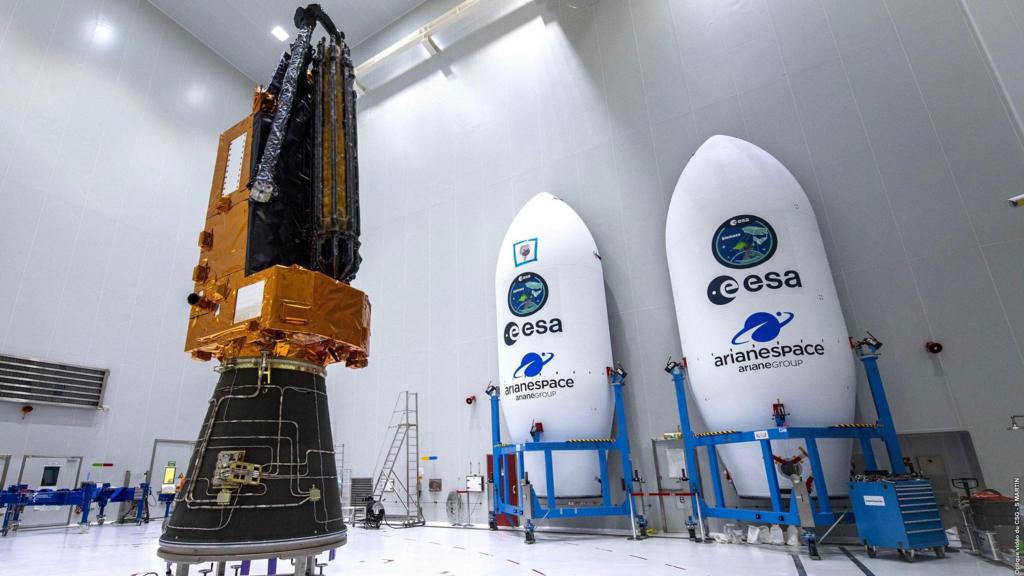
On Tuesday, the European Space Agency (ESA) successfully launched a pioneering satellite equipped with advanced radar technology that enables scientists to peer beneath the forest canopy.
Researchers hope the data it provides will deepen understanding of forests’ critical role in carbon storage and the effects of deforestation.
Lifting off from ESA’s Kourou facility in French Guiana, the rocket soared over the Amazon, one of the major rainforests to be surveyed.
The onboard satellite, nicknamed the “space brolly” for its 12-metre-wide antenna, will emit signals as it orbits.
“We really want to interrogate these forests. We can actually look inside,” said Professor John Remedios, director of the National Centre for Earth Observation and key proponent of the mission, following the launch.
He described as “major” the prospect of knowing, with unprecedented precision, the carbon content of forests in the Amazon, Congo, and Indonesia.
The satellite’s P-band radar features an exceptionally long wavelength, allowing it to penetrate the forest canopy and reveal branches and trunks hidden from conventional observation.
“Most spaceborne radars today capture striking images of icebergs but typically register only the forest tops—the small twigs and leaves. They don’t reach deep into the forests,” explained Dr Ralph Cordey, head of geosciences at Airbus.
“By employing a much longer radar wavelength, we can now probe the inner structure of forests,” he added.
The 1.2-tonne satellite will utilize an approach akin to a CT scan, analyzing numerous cross-sections on repeated passes, gradually constructing a comprehensive image of woody biomass present.
This woody material serves as a valuable proxy for estimating the volume of climate-warming carbon dioxide stored within.
Until now, scientists have had to measure individual trees and extrapolate these results—a “huge challenge,” according to Professor Mat Disney, remote sensing specialist at University College London.
“Our current estimates are patchy, simply because it’s extremely difficult to quantify. Essentially, it’s an attempt to measure the carbon content across more than a trillion tropical trees,” he noted.
“Satellites ultimately provide the only consistent method for achieving this scale of measurement.”
Ground-based data collection will continue alongside the satellite’s mission to validate the information received from orbit.
Constructed in the UK and initially conceptualized by Professor Shaun Quegan of the University of Sheffield, the satellite is the product of international collaboration: “This mission reflects decades of innovation involving top scientists across Europe and the US.”
Despite extensive preparations, several complex stages remain following launch, including challenging satellite deployments.
“Some elements, such as the deployable 12-metre antenna, present unique challenges—it’s similar to opening an enormous umbrella in space, and smooth deployment will be crucial,” Dr Cordey commented.
Airbus enlisted engineers from US-based L3Harris Technologies to assist in building the antenna-reflector at its Stevenage site.
L3Harris brings specialist expertise in manufacturing large, unfurlable space systems—capabilities not yet developed in Europe.
The consortium aims to deliver the first biomass maps within six months and to continue gathering data over a five-year period.
These annual maps will chart both the carbon stored and losses resulting from ongoing deforestation.
“Existing satellite observations, such as from Landsat over the past five decades, have often been obscured by cloud cover—particularly problematic in tropical regions,” said Professor Disney.
The long-wavelength radar of the Biomass satellite alleviates this challenge, penetrating clouds to provide reliable, year-to-year data on forest structure.
This capability has motivated the dedicated teams who have worked on the project for over two decades.
“It’s exciting, because the findings will deepen our understanding of forests and trees—resources often taken for granted—and their critical role in global processes driving climate change, both now and in the future,” Dr Cordey observed.
Subscribe to our Future Earth newsletter for exclusive updates and insights from BBC Climate Editor Justin Rowlatt, delivered weekly. Outside the UK? Sign up for the international edition here.
Tourism companies in Wales may qualify for up to £20,000 from the government to invest in “weather-proofing” operations.
Discover strategies to protect yourself from harmful UV exposure.
Wales could face a “radically changed future” without immediate action, warns the Future Generations Commissioner.
Ten years of conservation progress were erased in a matter of days by a wildfire in Glen Rosa valley.